The Shadow of the Tourist and the Lines of Desire in the Digital City
by Alex M. Ingersoll
[ PDF version ]
From the act of leisurely strolling through the streets to a tactical engagement with power, the experience of walking the city has encompassed a range of meanings and uses. Today, the dynamic interactions between information and geographic space have only added to these discussions.[i] Both computer engineers and technologically equipped users have been moving towards ways of merging information technologies with the physical spatiality of everyday life. Locative media (or location-based services) are one example of devices and applications in which the user’s precise geographical context becomes a determining factor for networked interactions. This paper is an attempt to contribute to the discussion surrounding mobility, technology, and space by focusing on a specific use of locative media. I point to a case that utilizes “data shadows” pulled from geo-tagging and public authoring platforms embedded within the popular photo hosting and sharing website, Flickr. This spatiotemporal data has not only provided a set of tools to illustrate the dynamics of mobility patterns in urban space; it has also been offered as a new service commodity. I argue that these locative devices are part of a broader “externalization of labor” in which the labor of the paid service worker is offset to the unpaid service customer.[ii] This externalization of labor is dependent upon broader reconfigurations of work by the tourist. In other words, the emergence of locative media has not only offered new forms of use-value for the tourist but has also positioned the tourist as the producer of exchange-value for others.[iii]
I will briefly analyze an application by computer engineer Fabien Girardin that uses locative media as a way to extract new forms of value from digital flows and tourist mobility. Girardin has utilized locational data sets to reconfigure the value of the tourist’s photo. Through the visualization of metadata, Girardin argues that value can be extracted out of mobility and high-level human behavior, information that would be “valuable to urban planners, traffic engineers, and tourism authorities.” The result is an aggregate system of data that visualizes “desire lines from digital traces” and offers the “tourist pulse” as a commodity form. In other words, this application determines and represents desirable times and spaces that are pulled from the collection of semantic descriptions and geovisualizations. The visualization of these data shadows combines the standard division of the tourist as worker—tourists as desiring voyeurs and tourists as quantifiable integers. I argue that such a reconfiguration of the work of the tourist through locative media compresses what Henri Lefebvre identifies as the key relations behind the production of social space: representations of space, representational spaces, and spatial practice.[iv] The increasing distortion of Lefebvre’s spatial triad through the operation of locative media serves as a platform for new configurations of work and labor, especially for the role of the tourist.[v]
Producing and Consuming Data Shadows
Since 2007, Fabien Girardin has been working with the Interactive Technologies Group in conjunction with the Massachusetts Institute of Technology on a project that he titles “Tracing the Visitor’s Eye.” This project utilizes what are called “data shadows,” which are traces of information that an individual leaves behind through networked communications. These shadows emerge from geo-tagging and public authoring platforms embedded within the popular photo hosting and sharing website, Flickr. When a user takes a photo and then uploads it to the website, it is tagged with an Exchangeable Image File Format (EXIF) to include the time and location of that particular image which results in a documented act of physical presence in time. For instance, if an individual takes a picture of the Colosseum and uploads that file onto Flickr’s servers, visitors to the website can view a range of characteristics about that image, including timestamps and spatial coordinates (usually translated into city/region information or identified directly on a map). When images are collected and the EXIF data is aggregated, the spatiotemporal information allows for tools that can illustrate mobility patterns in urban space. The data is arranged chronologically and then visualized with various colors over satellite imagery. The result is a map that reveals a pulsating, vibrant space where various mobile crowds flow throughout the city. These real-time digital guides illustrate the movement of individuals through neighborhoods in the course of a day and pose questions about whether high amounts of crowd density are related to the desirability of that space or wider problems with mobility. With these visualizations, both users and producers can interpret and react to the shifting urban environment and take a peek into the rhythms of everyday life.
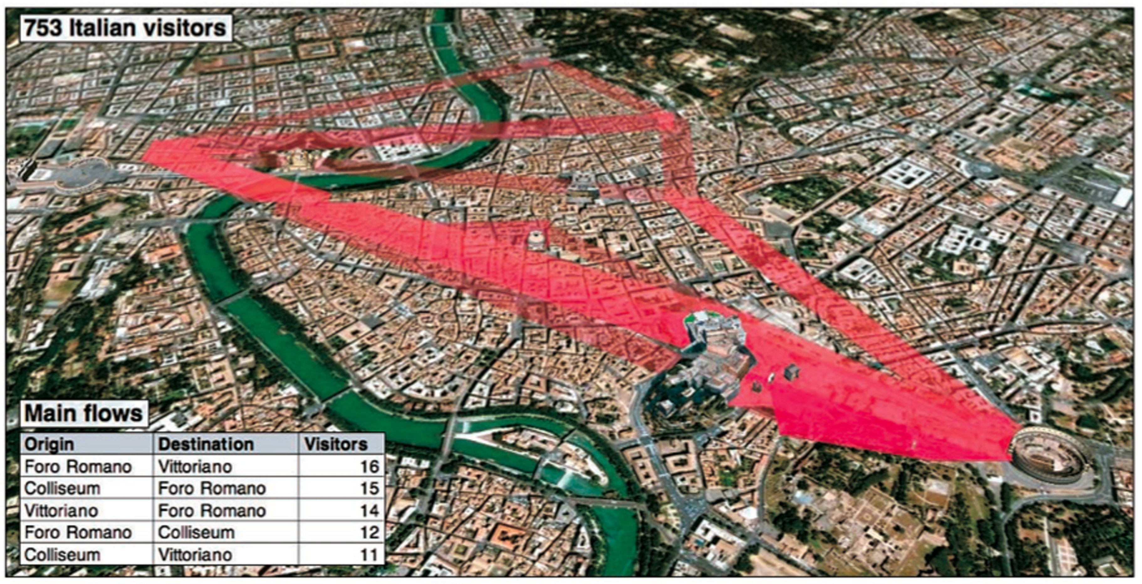
Figure 1. Italian visitors to Rome. Source: “Tracing the Visitor’s Eye”
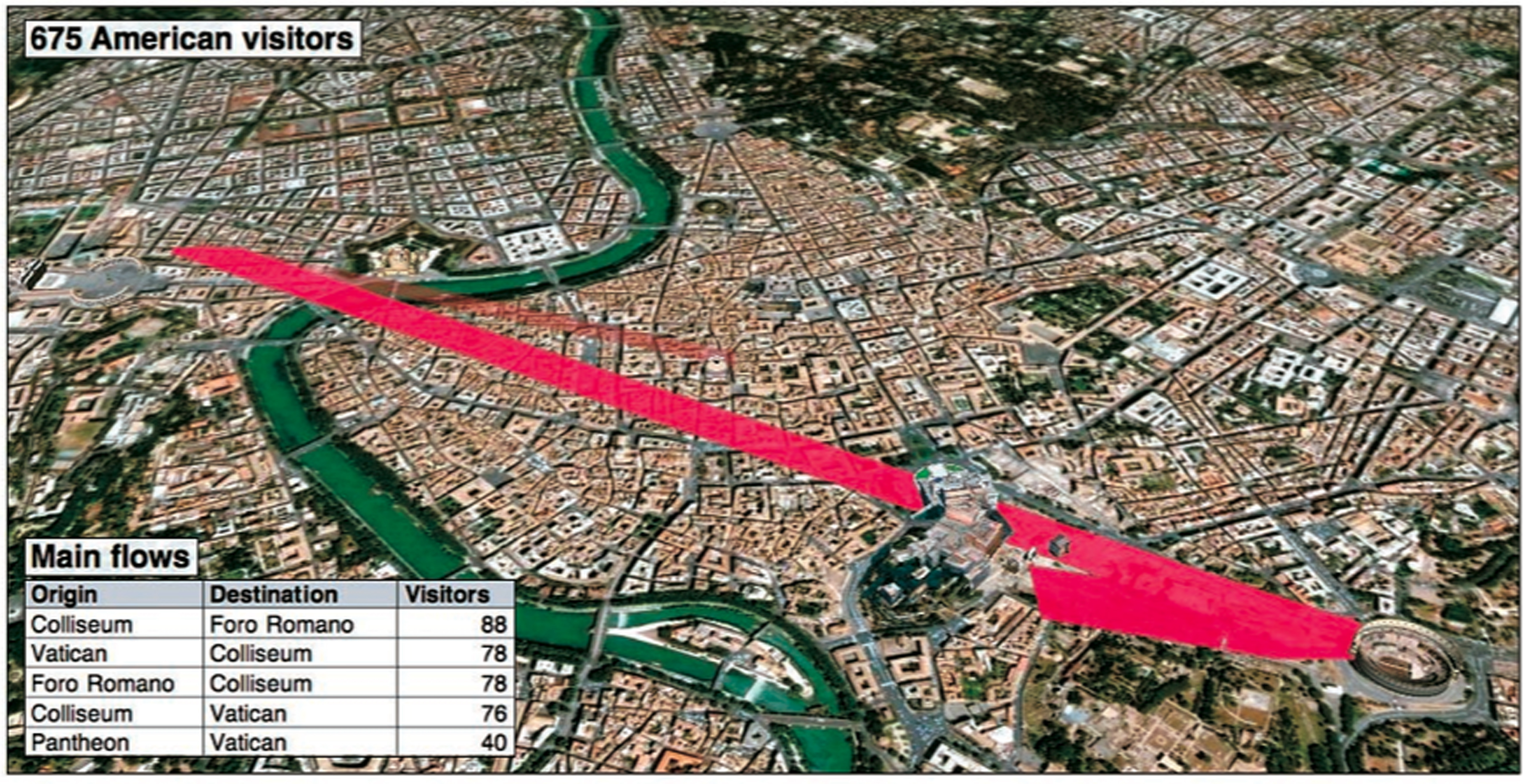
Figure 2. American visitors to Rome. Source: “Tracing the Visitor’s Eye”
The visualizations of tourist flows can be adapted according to a range of the informational categories that are collected. The two images above reveal that the main paths of movement between points of interests in Rome are significantly distinct for photographers of different nationalities. The 753 visiting Italian photographers move across more areas of the city when compared to the 675 American visitors who stay on a narrow path between more tourist-friendly sites such as the Vatican, Forum, and Colosseum. These visualizations reveal that the languages of the tourists are directly tied to the spaces that they are able to move through. This is a key component for urban planners as the shifting layers of language become just as important as material infrastructure. The visualized flow of bodies and data underscores the complex relational spatial configurations that have always existed in the urban environment. However, these visualizations also point to a situation in which various components of embodied mobility can be rendered visible or invisible by the individual who can manipulate this aggregation of data. The intricate spatial configurations become simplified flows of pixels moving through the streets of the city.
For this locative media project, the act of taking a picture on a digital camera and uploading it to a photo sharing service allows for an engaging range of applications, including new ways of interacting with spatiotemporal mappings of contemporary urban space and the individuals operating in it. However, Girardin positions the tourist as the worker that generates these new visualizations of space and is valued for revealing the consumption of urban space:[vi]
Our approach is to consider that uploading, tagging and disclosing the location of a photo can be interpreted as an act of communication rather than a pure implicit history of physical presence. For this purpose, we retrieved from Flickr, large amounts of photo [sic] taken by thousands of users in the world’s most photographed cities. Based on the time, explicit location and people’s description of their photos, we design geovisualizations. They reveal patterns of tourists and citizens consuming a city, such as the flow of people between city attractions... areas of influence or what is happening with day/night and working/weekend periodicity.[vii]
This statement is compelling for a number of reasons. First, there is the consideration of uploading and tagging these photos as an act of explicit disclosure and, thus, an act of public communication. This configuration not only attempts to align the project within the realm of public communication and away from the specters of surveillance; it also highlights the reconfiguration of work itself. This reconfiguration is dependent on a transformation of social space as daily private life is translated into a public logic that could be open to categorization by governmental or corporate control (depending on who utilizes the data). This transformation is rooted in a deeper history of urban spaces being integrated into wider symbolic economies. As urban sociologist Sharon Zukin argues, the symbolic economy aligns two production systems that become central to a city’s material life: “the production of space, with its synergy of capital investment and cultural meanings, and the production of symbols, which constructs both a currency of commercial exchange and a language of social identity.”[viii] The central struggle to determine who will dominate, use, live in, and profit from physical space in the city are increasingly battles over the entanglement of economics, culture, and everyday life. In addition, the blurring of the distinction between public and private space in the city generates an aura of freedom of choice for consumers while individuals that are not desirable consumers or do not have the latest technologies are either pushed out or marginalized.
Second, by linking these communication acts to an overarching mode of “consuming a city,”[ix] Girardin’s project is positioned alongside a deeper trajectory of extracting value from urban mobility. The general growth of consumption and production in the twentieth century mirrors not only the spread of suburbanization and the growth of exurbia but the growth of mobile technologies and the transformation of public space as well. Girardin’s visualizations underscore the ways in which productive space and the mobile subject are at the heart of efforts to determine the nature of how mobile populations consume space. The prospect of commercial use from such aggregated data is rooted in a reconfiguration of the work of the tourist as productive labor that would be efficient and profitable for urban planners, traffic engineers, and tourism authorities. Henri Lefebvre anticipates such configurations of labor and mobility and characterizes them as the “productive consumption” of space, whereby increased mobility stimulates an escalation of the ideology of production. Lefebvre notes, “This sequence of operations implies a productive consumption: the consumption of space…What actually happens is that a vicious cycle is set in train which for all its circularity is an invasive force serving dominant economic interests.”[x] For Lefebvre, this social production of space is fundamental to the reproduction of society and of capitalism itself. I view the wider implementation of locative media as a key component of the contemporary production of space. The work of the tourist to tag their uploaded photos with spatiotemporal data creates new fields of valuation, not just use-value for the tourist but exchange-value for architects seeking to build material infrastructure or urban planners adjusting a community’s public, commercial, and transportation spaces and mobilities.
The visualization of the mobile tourist allows for more efficient modes of valuation associated with the tourists’ location, multiple levels of popularity, duration, and mobility patterns, eventually eclipsing older models that are dependent on origin-destination statistics and surveys:
In tourism and urban planning, information about who populates different parts of the city at different times can lead to the provision of customized services (or advertising), accurate timing of service provisions based on demand (e.g. rescheduling of monument opening times based on the presence of tourists), and, in general, more synchronous management of service infrastructures.[xi]
An important application of these location-based services is the ability to incorporate aleatory systems into a form that links network movements to movement across urban space. Spatial and temporal presence (and non-presence) become important ways to use data shadows for flexible urban spatial reconfiguration. Therefore, the tourist’s flow through network infrastructure has a material effect on future material configurations of that urban space. In addition, by developing points and patterns of interest from the transitory urban visitor, this system of aggregated locational data allows Girardin not only to commodify mobility but also lines of desire. These “desire lines” can be linked with a number of other informational matrices including basic demographics such as nationality, sites where the tourist came from, where the tourist went, and associated semantic descriptions. As locative media applications become more widespread, it is important to critically engage how new commodity forms and labor arise out of the relations between digital and material environments.
Rhythmanalysis and the Collapsing Spatial Triad
It has been argued that the dominant version of modernity is rooted in a hegemony of vision and that tourism itself can be understood as one specific crystallization of this hegemony.[xii] Yet, long before the contemporary understanding of the tourist industry, archetypal examples of the category of leisure travel like the Grand Tour were based on learning languages, speaking to locals, and gathering facts.[xiii] These early notions of the “tourist” were of a completely different sort compared to the modern version of the mobile class. However, during the eighteenth century the dominant emphasis of tourism quickly shifted from the ear to the eye. The ascendancy of vision within tourism, as with other realms of modernity has been commonly associated with increasing complexities of power relations.[xiv] John Urry’s concept of the “tourist gaze,”[xv] for example, directs our attention toward the flexible relations of power among tourists and locals alike. The gaze quickly became a process of consumption as material sites became visual sights. Dean MacCannell’s foundational work on tourism broadens this argument by pointing to the historical formation of a “leisure class” through the tourist viewing the sights of the city. He characterizes the very act of sightseeing as “uniquely well suited among leisure alternatives to draw the tourist into a relationship with the modern social totality” since it allows the individual to “step out into the universal drama of modernity.”[xvi] For MacCannell, tourism is seen to fulfill the ideological function of positioning the individual within a wider social field as “individuals happily embrace the attitudes and norms that lead them into a relationship with society through the sightseeing act.”[xvii]
Girardin’s case illustrates the continuing dislocation of work and productive subjectivities out of the value of the sightseeing act through the tourist’s own consumption of space. This utilizes the power of the tourist’s lines of desire and re-routes this desire back into the configuration of that space itself. This circular process of commodification of metadata is dependent upon the externalization of unpaid labor, in which “activities taking place outside the money economy for use or exchange … move into the money economy and [are] replaced by craft production or consumer services that, generally taking advantage of technological innovations, become the basis of new manufacturing industries which in turn give rise to new service industries.”[xviii] The generation of new modes of consumption prompts new forms of consumption activities as well as new forms of unpaid labor as this “wheel of development” multiplies the increasingly complex social division of labor. Importantly, this case points to the spatial axis upon which the interdependence of technology, labor, and mobility revolves.
In a sense, location-based services are a digital manifestation of the “rhythmanalysis” project that Lefebvre theorized would “show the relations between everyday life and rhythms, which is to say the concrete modalities of social time.”[xix] Such a project is meant to underscore the empowering possibility of understanding an individual’s rhythmic presence in space as the “rhythmanalyst” seeks to determine the “facts of both nature and culture, at the same time sensible, affective and moral rather than imaginary.”[xx] Lefebvre viewed rhythmanalysis as an impressionistic and descriptive methodological tool for identifying the rhythms of social actors and groups that are enmeshed in the social production of space. In addition, Lefebvre viewed these rhythms as a struggle between an external, imposed sense of temporality and more endogenous cadences of everyday life. For him, the identification of these rhythms was a method for political intervention. However, I would argue that the rhythms of everyday life have been folded within the collapse of the spatial triad of the social production of space that Lefebvre outlines in his earlier work. The representations of space (or conceptualized space), representational space (or the directly lived space), and spatial practices are all becoming indistinguishable as the visualized rhythms and role of the tourist rapidly overlap with these interrelationships. In other words, the effect of location-based services on the relations between the conceived, perceived, and lived space compresses the social production of space so that the tourists serve as an instrument where all three nearly simultaneously occur.
Girardin’s “Tracing the Visitor’s Eye” is a rhythmanalysis system that manages to subvert the gaze of the tourist in ways that are not only subject to the powers of surveillance but towards a productive consumption as well. These digital photographic sharing services establish and extend “sociotechnical geometries of power” and serve as a foundation for reconfigurations of work and value.[xxi] Indeed, the hybrid spatial aggregates emerging out of the combination of media and urban mobility systems have become a strategic site of capital formation. While theorists in the last thirty years have tended to rely on “an overemphasis on the hypermobility of capital” that leads towards the purported negation of space through digital communication technology,[xxii] efforts are now being made to extract value out of geographically bounded network interactions. Indeed, the value of the mobile tourist in the digital city is rooted in networked data shadows being mapped back onto and through geographic space.
Notes
[i] There is a significant amount of literature on the role of urban space in relation to the mobile individual and modernity. I am briefly referring to Charles Baudelaire, The Painter of Modern Life (New York: Da Capo Press, 1964); Walter Benjamin, Charles Baudelaire: A Lyric Poet in the Era of High Capitalism, trans. Harry Zohn (New York: Verso, 1983); and Michel de Certeau, The Practice of Everyday Life, trans. Steven Rendall (Berkeley, CA: University of California Press, 1984).
[ii] Ursuala Huws, The Making of a Cybertariat: Virtual Work in a Real World (New York: Monthly Review Press, 2003), 182.
[iii] This juxtaposition of “work” and “labor” is influenced by a footnote by Friedrich Engels in Karl Marx, Capital Volume 1, trans. Ben Fowkes (London: Penguin Books, 1990), 138. See also Hannah Arendt, The Human Condition (Chicago: The University of Chicago Press, 1958).
[iv] Henri Lefebvre, The Production of Space (Oxford: Blackwell, 1991).
[v] For more on interactive technologies and forms of unpaid labor from offloading the costs of the workplace onto workers, see Mark Andrejevic, iSpy: Surveillance and Power in the Interactive Era (Lawrence, KS: University Press of Kansas, 2007).
[vi] The inherent value of the tourist gaze, location and mobility involves a measurable distinction between a tourist and a resident of an urban space. For this case, Fabien Girardin and his associates examine the duration of the photographer’s presence in that space, setting an arbitrary limit for a tourist’s visit at thirty days. If the images reveal that the photographer took photos for more than thirty days in a row, the system considers that individual to be a resident and perhaps, less valuable to specific organizations.
[vii] Fabien Girardin, “Tracing the Visitor’s Eye,” http://www.girardin.org/fabien/tracing/ (accessed 14 December 2010). Emphasis added.
[viii] Sharon Zukin, The Cultures of Cities (Oxford: Blackwell, 1995), 23-24.
[ix] Girardin, “Tracing the Visitor’s Eye.”
[x] Lefebvre, The Production of Space, 374.
[xi] Fabien Girardin, Francesco Calabrese, Filippo Dal Fiorre, Assaf Biderman, Carlo Ratti, and Josep Blat, “Uncovering the Presence and Movements of Tourists from User-Generated Content,” 9th International Forum on Tourism Statistics (2008): 1.
[xii] See David Michael Levin, Modernity and the Hegemony of Vision (Berkeley: University of California Press, 1993); and Carol Crawshaw and John Urry, “Tourism and the Photographic Eye,” in Touring Cultures: Transformations in Travel and Theory, ed. Chris Rojeck and John Urry (London: Routledge, 1997), 176-195.
[xiii] “The Grand Tour” was the traditional travel pilgrimage that was undertaken throughout Europe and was managed by upper-class European young men (typically following the conclusion of higher education). This custom flourished from about 1660 until the introduction of large-scale railroad transit systems in the mid-nineteenth century and was typified by a standard itinerary. See Edward Chaney, The Evolution of the Grand Tour (London: Frank Cass, 1998).
[xiv] See Judith Adler, “Travel as Performed Art,” American Journal of Sociology 94 (1989): 1366-1391; and Michel Foucault, Discipline and Punish: The Birth of the Prison (New York: Vintage Books, 1977).
[xv] John Urry, The Tourist Gaze: Leisure and Travel in Contemporary Societies (London: Sage, 1990).
[xvi] Dean MacCannell, The Tourist: A New Theory of the Leisure Class (Berkeley: University of California Press, 1977), 7.
[xviii] Ibid., 55. Major concepts in tourism research that have been derived out of MacCannell’s work, such as John Urry’s notion of the tourist gaze, have tended to endow the tourist behind the camera with a significant amount of power (e.g., Crawshaw and Urry, “Tourism and the Photographic Eye.”). Urry is primarily concerned with the construction of the tourist perspective and the way in which places are appropriated for experience and communication by different social groups in different epochs. This is primarily rooted in his argument that there “is no single tourist gaze as such. It varies by society, by social group and by historical period” (Urry, The Tourist Gaze, 1).
[xviii] Huws, Making of a Cybertariat, 17.
[xix] Henri Lefebvre, Rhythmanalysis: Space, Time and Everyday Life (London: Continuum, 2004), 73.
[xx] Ibid., 23.
[xxi] Doreen Massey, “Power-Geometry and a Progressive Sense of Place,” in Mapping the Futures: Local Cultures, Global Change, ed. Jon Bird, Barry Curtis, Tim Putnam, George Robertson, and Lisa Tickner (London: Routledge, 1993), 59-69.
[xxii] Saskia Sassen, Globalization and Its Discontents (New York: The New Press, 1998), 195.
Alex M. Ingersoll is a Ph.D. student in the Department of Communication Studies at the University of North Carolina, Chapel Hill. He researches media technology and space, and is particularly interested in the technologies of spatial representation, orientation, and navigation.
 Post a Comment