Museum Maps and the Edge
Melissa Forstrom
[ PDF Version]
There are two types of maps that are present in museums: wayfinding maps and geographic maps. Wayfinding maps are distributed/available to museum visitors for the purpose of representing the spaces of the museum so that visitors are able to find their way. Geographic maps, which are the focus on this paper, are usually mounted on the wall as part of an exhibition and interpret and communicate geographic space to the museum visitor. They are typically produced or commissioned by the director of a curatorial department to represent geographic spaces that are relevant to the objects of an exhibition for the orientation of visitors.[1] Geographic maps are frequently present in exhibitions as part of an interpretation strategy[2] that is separated from the geography and/or chronological time in relationship to the museum location/audiences.[3] Therefore, the presence of a geographic map could indicate that the visitor is not expected, or imagined by exhibition creators to be familiar with the geography relevant to the exhibition/art.[4]
The museum as the context in which maps appear is important for two interrelated reasons. The first is that museums hold a privileged and influential position in society.[5] This is because audiences endow museums with the attributes of veracity, authenticity and credibility.[6] Therefore the influence of museums resides in the authority that is given to them by its visitors. Indeed museums are trusted and believed to be highly credible sources of information by audiences.[7] Second, museums are perceived to be objective.[8] Rarely, if ever, is the interpretation available in museum spaces questioned, believed to be subjective, and/or specific to the interests/expertise of exhibition creators.[9] Hence, in addition to the authenticity, credibility and trust that are associated with museums, they are believed to be objective by audiences.
Similar to museums, maps are also believed to be objective.[10] Therefore, the museum as the context that a map appears allows for an intensification of objectivity. This is because of the perceived objectivity that is already afforded to museums by its visitors. However, maps are not objective, they are selective representation of reality that are designed to display points and relationships, which illustrate power relationships.[11] The illustrated power relationships embody a world-view[12] that contains the values of the dominant groups and in this case, the exhibition creators.
What has not been selected to be represented is hence excluded and could be deemed to be unimportant by exhibition creators. The concept of exclusion or omission in map theory is termed a “silence”.[13] Through exclusion, a map silence exerts a “social influence” which can be described as an ideological filtering that reveals the potential biases of its' creators.[14] In this paper, I examine museum maps as an edge-making media and initiator of silence in the Louvre’s Art of Islam exhibition that elucidates the potential ideological filter and biases of the exhibition creators.
Edges and Silences in the “1500-1800, Three Modern Empires of Islam” panel
The reinstallation of the Arts of Islam exhibition (2012) at the Louvre is part of a much larger trend, in which all major collections of Islamic art[15] in Europe, Russia and the United States have been reinstalled in the past twenty years. This includes large institutions like Metropolitan Museum of Art (2011, New York), the Hermitage (2014, Saint Petersburg), and the British Museum (2018, London) to smaller institutions including the David Collection (2009, Copenhagen) and the Detroit Institute of Arts (2010). In total, there are over twenty reinstalled Islamic art collections currently and with others planned such as the Los Angeles County Museum of Art and Brooklyn Museum of Art. Consequently, Islamic art is probably the most consistently reinstalled art historical field ever and most certainly in the past twenty years.[16] As a result of the reinstallations, Islamic art collections have been reevaluated and reinterpreted. Often geographic maps are part of the interpretation strategies employed in Islamic art reinstallations probably because of the separation from the geography and chronological time in relationship to the exhibition location.
The Arts of Islam exhibition was curated by Sophie Makariou and houses over 2,500 Islamic art objects from the seventh to the nineteenth centuries. The organization of the galleries is separated into four chronological sections.[17] In each chronological section a written interpretation panel[18] interprets mostly the historical and military history of a particular time period. Identical in layout, each panel has specific segments. Beginning with the title, each panel has chronological and written title. Underneath the title is written interpretation in three languages: French, English and Spanish.[19] The bottom of the panel includes a timeline of the chronological period. Directly to the right of the written interpretation is a map of the majority of the eastern hemisphere. These maps are illuminated by moving or animated colored lights to represent the geographic spaces where Islam was (at that chronological time) the predominant religion, the boundaries of an empire and/or military conquests.
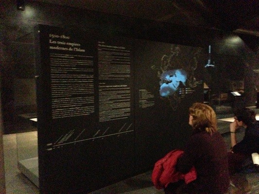
Figure 1. “1500-1800, Three Modern Empires of Islam” Panel image.
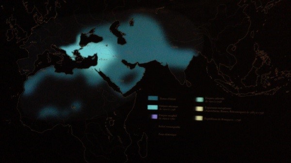
The “1500-1800, Three Modern Empires of Islam” panel is the fourth chronological panel in the Arts of Islam exhibition. This map has at least two edges. The first is the static map edge that is principally defined by the representation of the eastern hemisphere and is unchanging.[20] The second edge, which is the primary focus of this paper, moves and changes through demarcated sections, which are indicated by colored illuminations (within the chronological time represented in the panel: 1500-1800). Below the map, there is a listing of these demarcated illuminated sections. They include: “Lands of Islam; Ottoman empire from 1500 to 1798; Mughal empire from 1500 to 1760, Safavid empire from 1503 to 1798; European expansion from 1683 to 1798; and Bonaparte expedition 1798”.[21] These sections, represented by different colors are then illuminated in two places simultaneously: in the listing below the map and within geographic spaces that these dynasties and invasions occupied during the 1500-1800 time frame. Illuminated or animated geographic maps are uncommon in exhibition interpretation strategies. As such, this paper asks: What silences could the moving edges initiate? And how do they illustrate an ideological filter that could reveal biases?
 <
<Click image for video recording of “1500-1800, Three Modern Empires of Islam”
Although the illuminated moving map edges could initially appear to be dynamic and engaging, a closer examination of the first four demarcated sections reveals possible Islamophobic and/or Eurocentric biases.[22] The “Lands of Islam” boundary remains consistently illuminated by a blue color throughout the illumination sequence. Within the “Lands of Islam” illumination, three diverse empires (Ottoman, Mughal, Safavid) are sequentially illuminated with different colors. Because the “Lands of Islam” includes the empires represented, the edges of the empires are engulfed in this religious association and because of this, the religion of Islam is the primary organizing principle or frame in which these empires are experienced by the exhibition visitor. Although subtle, the “Lands of Islam” edge, could be illustrative of an Islamophobic bias where Islam is represented as a monolithic bloc and an insensitivity to the diversity of Muslim peoples.[23] This edge silences the diversity of the Ottoman, Mughal and Safavid empires each of which practiced different branches of Islam (the largest branches being: Sunni, Shia, and Sufi), the specificity and political complexity of each empire and the various agreements for the exchange of art and goods with European counterparts.
The remaining illuminated map sections are titled “European expansion from 1683 to 1798” and “Bonaparte’s expedition 1798”. The expansion is only representative of 115 years within the three hundred year period represented by this panel. Even more bizarrely, “Boneaparte’s expedition 1798” is only representative of a single year. Although these relationships could be important in the histories of how the art in the galleries have been acquired, no explicit connection is communicated to the visitor and therefore, this inclusion could be interpreted as Eurocentric.
The representation of these sections is extraordinary not only in its inclusion, but also in that the “European expansion” section includes the lands gained by Europeans invasions in relationship to the “Lands of Islam” illumination and not that of the Ottoman, Safavid and Mongol empires respectively. The edges of these empires are therefore silent. As such, these inclusions draw attention to the edge of “European expansion” which is defined by its relationship to the edge of the “Lands of Islam”. Therefore the map is explicit in that European expansion takes place in opposition to Islam, as the primary association and not the respective empires on the map. Again, the religion of Islam is the primary organizing principle or frame in which European invasion is experienced by the exhibition visitor. These edges and subsequent silences could promote a “clash of civilizations” rhetoric where people’s religious identities are the primary source of conflict since the end of Cold War.[24] These edges could also be reminiscent of where Islam is seen as threatening and in support of this “clash of civilizations” rhetoric that has been identified as an Islamophobic worldview.[25] The silence of empire is potentially problematic in that European powers including France were not fighting against, “Islam” or the “The Lands of Islam”, but particular empires in which Islam was the predominant religion.
The “Lands of Islam” edge is therefore, distinct and separate from European experiences. The edge draws a definitive boundary and silences the intercultural and artistic exchange happening within and between these empires and their European counterparts. Furthermore, this edge marks the religion of Islam as the only organizing principle in which these empires and European invasions are made visible and experienced by the exhibition visitor.
In conclusion, the reinstallation of major Islamic art collections in United States, Russia and Europe in the past twenty years means that these collections have been reinterpreted. Because the production of Islamic art is separated by geographic space and chronological time from places of exhibition, often geographic maps are created as part of the interpretative strategy in these exhibitions. Museum maps are an edge-making media that initiate and elucidate map silences, which can reveal the potential biases of its’ creators. Silences created by the moving edges of the “1500-1800 The Three Modern Empires of Islam” map include Islam becomes the primary organizing principle, in which Islam is experienced as a singular monolithic bloc devoid of diversity. Further perpetuating a Eurocentric world-view is the inclusion of sections specific to the French or European experience in opposition to the “Lands of Islam” edges and not the Ottoman, Mughal and Safavid empires respectively. These inclusions and silences could promote a Eurocentric and/or clash of civilizations/Islamophobic worldview. In order to avoid such readings of exhibition interpretation, exhibition creators could, through self-reflection and/or interpretative theory resources[26] examine interpretation that have the potential to inadvertently perpetuate these biases.
Notes
[1] Melissa Forstrom, “Interpretation and Visitors in Two Islamic Art Exhibitions” (PhD diss, University of Westminster, 2017): 62.
[2] Interpretation strategies are developed by exhibition creators using a variety of media to convey selective messages to its’ audiences. As such, museums are mediatized spaces. The analysis of museum interpretation is grouped under interpretative theory in museum studies and can include written texts, exhibition design, lighting, art placement, digital, audio guides, and maps, etc.
[3] Forstrom, Interpretation and Visitors in Two Islamic Art Exhibitions”, 63.
[4] Christopher Whitehead, Interpretation in Art Museums and Galleries (New York: Routledge 2012): 47.
[5] Richard Sandell, Museums, Prejudice and the Reframing of Difference (New York: Routledge, 2007): 132.
[6] Sandell, Museums, Prejudice and the Reframing of Difference, p.174.
[7] Colleen Dilenschnedier “People Trust Museums More than Newspapers. Here is Why that Matters Right Now”, last modified April 26, 2017, https://www.colleendilen.com/ 2017/04/26/people-trust-museums-more-than-newspapers-here-is-why-that-matters-right-now-data/.
[8] Helen Coxall, “Whose Story is it Anyway? Language and Museums” Journal of Museum Ethnography 12 (2000): 87.
[9] This claim is based on the visitor research that I have undertaken at the Metropolitan Museum of Art (May 2014), the Walters Art Museum (January 2016) and ongoing at the New Museum of Contemporary Art (ongoing 2019).
[10] For a discussion on the objectivity of maps see: Daniel Dorling and David Fairbarin, Mapping: Ways of Representing the World, Insights into Human Geography Series (London: Longman): 4. For a discussion on the similarities between the perceived objectivity of maps and museums see: Melissa Forstrom “Maps in the Museum” (paper presented at New York Public Library, New York, NY, 7 January 2015).
[11] For a discussion of representation in maps, see: Dorling and Fairbarin, Mapping: Ways of Representing the World, 6. For a discussion on the illustration of power relationships see: Jeremy Black, Maps and Politics (London: Reaktion Books, 1998): 11-2.
[12] Dorling and Fairbarin, Mapping: Ways of Representing the World, 3-4.
[13] Harley, The New Nature of Maps, 67.
[14] Harley, The New Nature of Maps, 67.
[15] Islamic art is inclusive of religious and secular art from historical (and in some definitions contemporary) places/dynasties where Islam is the dominant religion, legal system and cultural influence. Usually, the Islamic art field is historicized, meaning that Islamic art is defined as being produced from the seventh to nineteenth centuries. Recently these historicized definitions are being challenged by some curators including Venetia Porter, Assistant Keeper, Islamic and contemporary Middle East at the British Museum and Linda Komaroff, Curator of Islamic Art at the Los Angeles Country Museum of Art.
[16] See: Forstrom, “Interpretation and Visitors in Two Islamic Art Exhibitions”, 2. Although part of a trend, it is also important to note that frequently these reinstallations are externally funded and each museum/department of Islamic art has individually specific reasons for the reinstallation.
[17] It is significant that the interpretative strategy employs only four chronological panels to interpret twelve centuries of art and 2,500 objects. This is unlike the majority of interpretative strategies employed in other major reinstallations such as the Metropolitan Museum, which has thirty panels that interprets twelve centuries of art and 1,200 objects, which is less than half on display in Arts of Islam at the Louvre.
[18] The term panel here can be defined as written interpretation in museum exhibition that interprets exhibition themes, gallery, and/or chronology. Panels generally have a significant physical presence in the museum spaces, have longer word counts and are larger than written interpretation that interprets an individual art object.
[19] It is important to note that no translation was available in the major languages associated with these geographic regions such as Arabic, Farsi and/or Turkish.
[20] The static map edge in the “1500- 1800, Three Modern Empires of Islam” panel is of the eastern hemisphere and includes most of Europe, Asia and Africa. Quite noticeably, the inclusion of only the eastern hemisphere initiates a silence of the western hemisphere or more specifically, the art and experience of Islam and Muslim peoples in the western hemisphere.
[21] These categories were listed in French in the “1500-1800, The Three Modern Empires of Islam” panel: Terres d’Islam; Empire ottoman de 1500 a 1798; Empire moghol de 1500 a 1760; Empire safavide de 1503 a 1798; Expansion européen de 1683 a 1798; and Expédition de Bonaparte 1798.
[22] Although Southeast Asian art is often not included in the canon of Islamic art and Islamic art collections, it is unclear why Southeast Asian nations like Indonesia and Malaysia are not illuminated on the map under the “Lands of Islam”. This could be because the Department of Islamic Art at the Louvre does not have art from these countries in their collections. However, it seems entirely historically inaccurate to illuminate “Lands of Islam” on a map without including these places where Islam was (and still is) the predominant religion. This silence could reveal the bias of a French or Eurocentric world-view. Importantly, the British Museum, which has one of the most recent reinstalled Islamic art collections titled The Islamic World (opened in October 2018) and was sponsored by the Malaysian Alburkary Foundation. With the opening of these new galleries, art from Southeast Asia was for the first time included at The Islamic World galleries at the British Museum.
[23] Gordon Conway (chair), The Runnymeade Trust, Commission on British Muslims and Islam, Islamophobia: A Challenge For Us All (1997): 5.
[24] Samuel Huntington, The Clash of Civilizations and the Remaking of World Order (New York: Simon & Shuster 1996).
[25] Conway, Islamophobia: A Challenge For Us All (1997): 5.
[26] See: Christopher Whitehead, Interpretation in Art Museums and Galleries (New York: Routledge 2012) and Cheryl Meszaros “Interpretation and the Art Museum: Between the Familiar and the Unfamiliar” Museum Gallery Interpretation and Material Culture (New York: Routledge 2011).
Melissa Forstrom is an Assistant Professor at SUNY Purchase, where she teaches courses in Museum Studies & Arts Management. She has been an invited lecturer at Johns Hopkins, University of Leicester, University of Oslo, and Humboldt University, amongst others. Melissa completed her doctoral dissertation (2017) at the University of Westminster (UK).
 Media Fields Journal